Kern River water to go into California Aqueduct to keep it out of Tulare Lake; flows to ramp up mid-June

For the first time in 17 years, the Kern River “intertie” will be opened on Monday to release Kern River flood waters into the California Aqueduct, according to the Kern River Watermaster.
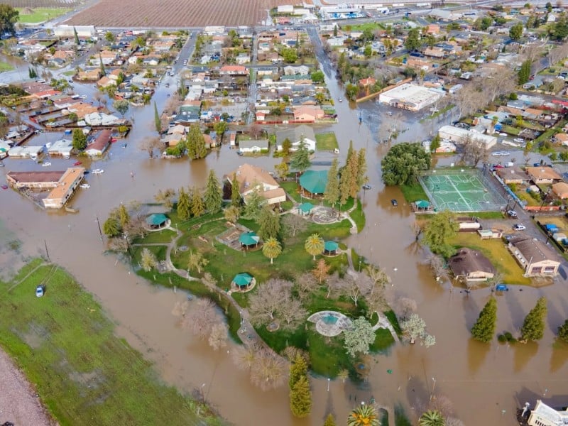
The move is an attempt to keep more flood water off the already waterlogged Tulare Lake bed as officials anticipate significantly increased Kern River flows starting in mid-June.
“The plan is to start with 500 (cubic feet per second) on Monday with an increase to 1,000 cfs on Saturday if everything is working properly,” Watermaster Mark Mulkay said of water going into the aqueduct. “Then we will review the numbers and see what happens next.”

River flows are expected to increase shortly to 7,500 cfs and could potentially go above 9,000 cfs in mid-June, according to Department of Water Resources estimates.
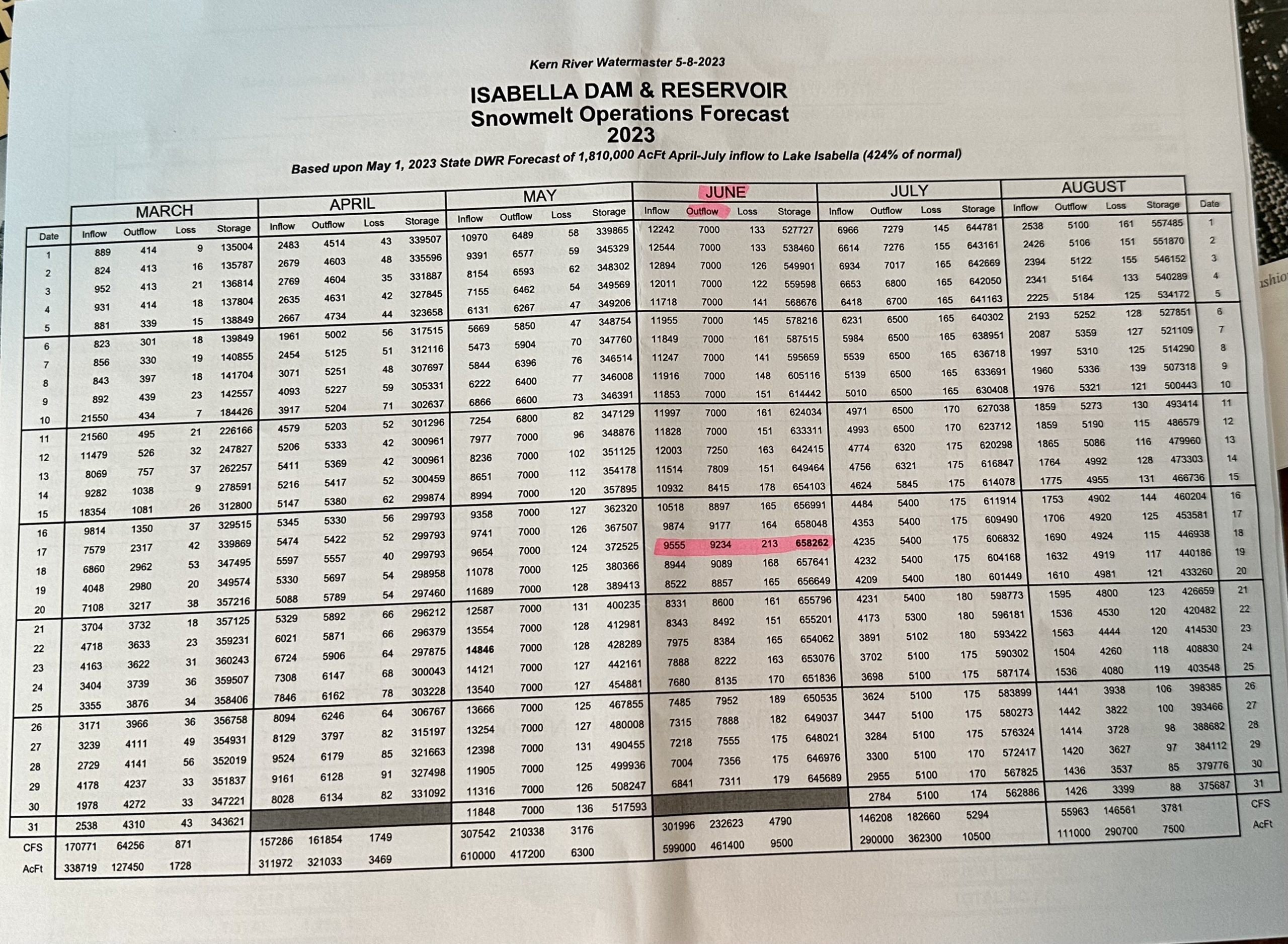
Lake Isabella is anticipated to fill beyond its maximum capacity, to 658,262, sometime in mid-June forcing outflows up to 9,234 cfs, according to a May 8 DWR estimate provided by Kern County Administrative Officer Ryan Alsop.
“June 12th through the 26th are the key dates of concern,” Alsop said. “Lake storage is expected to go up over that time period and that could mean a spike in releases.”
The goal is to avoid damaging outflows by moving releases up now to 7,500 cfs he said. He stressed that all of these numbers could change depending on weather.
He also noted that outflows from the dam are not the same as what the public sees through town because there are so many canals taking water off the Kern River, starting with the Beardsley Canal just east of China Grade Loop.
Dam outflows on Friday, for example, were 6,750 cfs. Streams throughout the canyon added more water so at the first point of measurement near Hart Park, the river was flowing at 6,884 cfs, according to a daily flow sheet provided by the City of Bakersfield.
By the time the river got to the Bellevue weir, near Stockdale Highway, the river was running at 2,930 cfs, well below the capacity of the river channel, which is 8,000 cfs, according to the Army Corps of Engineers.
“The flow through the city looks good,” Alsop said. “But we do have areas of concern mostly from Manor Street to the east.”
Officials are watching other areas, including the Heart Hospital at Sillect Avenue near the river, but they don’t believe it’s in imminent danger, Alsop said.
If outflows go above 7,500 cfs for any length of time, flooding is expected in some low lying areas along the river, Alsop said. Those include areas from about Hart Park to Manor Street.
To give the public an idea of what to expect on the river through those areas, he said, as outflows rise, every 1,000 cfs increase will mean another one to two feet increase in river elevation, depending on river channel width.
That’s important information for folks living near the banks of the river who aren’t protected by a levee.
Alsop said the county has been going door to door in those low lying areas checking on residents and providing sandbags at Sam Lynn Ballpark and Round Mountain and Goodmanville roads.
“Residents have been taking them as quickly as we’ve been putting them out there,” he said in answer to reports that people are finding empty pallets. He added the county would be putting equipment on site that can make sandbags rapidly to ensure residents have enough.
The Kern County Fairgrounds will be opened for residents in the Goodmanville/Manor areas to bring livestock, if needed.
Through most of the City Bakersfield, the river is flanked by levees that are rated by the Federal Emergency Management Agency to withstand flows up to 10,200 cfs, according to Bakersfield Water Resources Deputy Director Daniel Maldonado.
Even so, residents have photographed new berms being placed in some areas, including near Calloway Road on the south side of the river. When asked why that is, the city has not responded.
If the lake goes above 600,000 acre feet, that will likely trigger use of the “service spillway” at Isabella Dam for the first time since 1983, according to an announcement from the Army Corps of Engineers. That should not be confused with use of the “emergency spillway,” which the Corps doesn’t anticipate happening.
The Army Corps has been trying to get outflows from the dam up to 7,500 cfs in order to make room in the lake for runoff from the historic snowpack as temperatures heat up.
The lake can hold a maximum 568,000 acre feet and was at 342,097 acre feet as of Friday morning. Inflows to the lake were matching outflows at about 6,740 cfs, per the Army Corps webpage that tracks flows hourly.
The ramp up to 7,500 cfs has stutter stepped however, with a brief cessation of all outflows on April 26 after a vibration was noted in the power plant at the foot of the dam. Flows to the plant through penstocks in the dam were stopped and rerouted through the dam’s gates.
Speculation was that trash on the dam’s intake gates may have caused the vibration but power plant operators Isabella Partners could not be reached for comment and the Army Corps has only said there was no vibration in its facilities.
Outflow also briefly dropped to 5,900 cfs on May 6 because downstream demand was down, Watermaster Mulkay said.