How low will it go? Kern agencies worry one district setting groundwater levels too far down

Kern County agricultural water districts are giving major side-eye to one of their own over what’s known as “minimum threshold” groundwater levels
The grumbling is aimed at the sprawling Semitropic Water Storage District in northwest Kern, where minimum thresholds are set, in some cases, at levels that would allow farmers to pump down the water table by more than 350 feet from where it is today. Its water levels are also often far below those of neighboring water districts.
“(Semitropic’s) minimum thresholds impact our water users,” said Dan Bartel, general manager of Rosedale-Rio Bravo Water Storage District, which sits east of Semitropic. “We can’t maintain our own minimum thresholds with much lower minimum thresholds around us.”
Minimum thresholds are a sort of groundwater red line under the state’s Sustainable Groundwater Management Act (SGMA). They represent the lowest level the water table can drop without worsening water quality, harming wells or adding to the chronic depletion of the aquifer. If groundwater agencies hit those minimum thresholds, that is supposed to be a trigger to enact measures to bring up the water table.
Water managers were supposed to calculate all those factors plus historic water tables in setting minimum thresholds as part of their groundwater sustainability plans filed with the state two years ago.
But the state Department of Water Resources found minimum thresholds inconsistent in the Kern subbasin and specifically called out Semitropic to explain how it came up with its levels. That was one of three deficiencies cited by DWR in finding Kern’s overall groundwater plan “incomplete” earlier this year. Groundwater agencies have until July to address those issues and resubmit plans to the state.
If DWR still finds them unacceptable, the whole Kern subbasin could be found non-compliant, which could potentially lead to enforcement actions by the State Water Resources Control board including pumping limitations, fines and steep fees for every acre foot pumped.
So, the stakes are high.
Some districts with lower minimum thresholds have agreed to bump them up in the face of that DWR evaluation.
“We have been working with neighboring districts and we’ve been able to coordinate minimum thresholds with all of them,” Rosedale-Rio Bravo’s Bartel said. “Except for Semitropic.”
For its part Semitropic said minimum thresholds are just one piece of the groundwater puzzle. Its groundwater plan includes a full suite of actions, some that have already been implemented, to make sure the water table doesn’t approach those minimum thresholds, said Jason Gianquinto, General Manager of Semitropic.
He said the water table in Semitropic has remained relatively flat in recent years because of actions the district has already taken to retire land, recharge water and reduce pumping.
“We’re not waiting until we get to those minimum thresholds before we do anything,” Gianquinto said. “We’ve given our landowners water budgets that ramp down over time and set rates to enforce those budgets.”
Still, Semitropic’s minimum thresholds and even its measurable objectives, higher groundwater levels that managers are supposed to try and maintain, are set significantly lower than historic and current water levels.
Groundwater monitoring wells detailed on the Kern Groundwater Authority data management system show the disparities in stark relief.
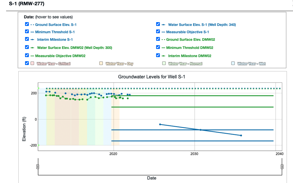
For instance, one of Semitropic’s wells called S-1 southeast of Lost Hills, show’s a groundwater level of about 189 feet above sea level. Yet, the minimum threshold for that well is 165 feet below sea level. That means farmers could, theoretically, pump enough to drop the water table another 354 feet before triggering the minimum threshold for that well.
One well in a specific hydrologic zone is not representative of the entire district, Gianquinto pointed out.
On average, he said minimum thresholds across the district allow for 189 feet of decline. But that’s only if the district did nothing to decrease pumping and increase recharge.
“If you look at water tables across the district, you will see a trend from 2000 to 2015 that shows a fairly steep downward slope,” Gianquinto said. “From 2015 to the present, the trajectory of that slope has started to flatten as we work toward the glide path that SGMA allows.”
Semitropic’s neighbors, however, are still concerned by the numbers.
For instance, a well owned by the Buena Vista Water Storage District, called DMW02 1.5 miles south of S-1, has a minimum threshold of 95 feet above sea level, or 260 feet above S-1’s minimum threshold in an area where groundwater naturally moves to the north.
Another well, northwest of Wasco shows the current water table at 116 feet below sea level with a minimum threshold of 331 feet below sea level, meaning the water table would have to drop another 215 feet to trigger action.
Northeast of Buttonwillow is Semitropic’s well 948L02 with a water table at sea level and a minimum threshold at 180 feet below sea level. Farmers could pump the aquifer down another 180 feet before that well would hit its minimum threshold. Just two miles south, a Rosedale-Rio Bravo well called 18 Cauzza has a water table of 20 feet above sea level and is already nearing its minimum threshold of 8 feet above sea level.
Gianquinto acknowledged Semitropic’s minimum thresholds are lower than its neighbors but said that’s part of Semitropic’s plan, which is based on a specific philosophy for how to comply with SGMA.
There are two schools of thought, he said. Should water districts simply stop all pumping and try to raise water tables all at once, causing severe economic pain? Or should managers institute more of a “glide path,” increasing recharge projects and decreasing pumping over time?
Semitropic chose the glide path.
“We are doing what we can to own and correct our share of Kern’s groundwater deficit.”
And it’s a big share.
Kern’s total groundwater deficit, more water pumped out than goes back in, is about 320,000 acre feet per year. Semitropic’s portion of that deficit is about 160,000 acre feet per year.
“SGMA gives us time to correct that deficit,” Gianquinto said. “So our philosophy has been to create a glide path toward sustainability. Our plan even says we will raise those minimum thresholds as we see things flesh out.”
It remains to be seen if the state will agree with that philosophy.