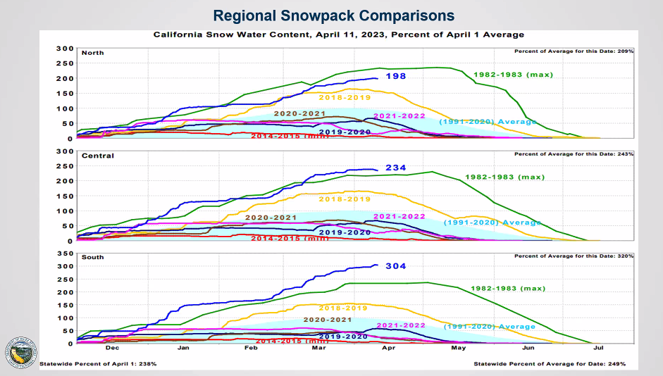
It’s unlikely that all the snow looming above the San Joaquin Valley will melt and barrel toward the valley floor at the same time.
If history is a guide, the melt should be staggered between the San Joaquin, Kings, Tule and Kern river watersheds starting later this month through July.
“That’s good,” said California Department of Water Resources Climatologist Michael Anderson during a press briefing on Tuesday. “It means not all the watersheds will see the same melt at the same time.”
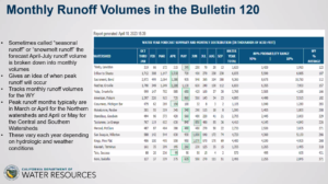
But there’s still going to be a massive amount of water coming down, according to DWR’s Bulletin 120, a monthly report that measures snowpack and water content across the Sierra Nevada mountains.
The report also estimates when to expect how much water downstream.
The numbers this year are stunning. 
Peak runoff on the Kern River, which has a snowpack at 429% of average, is estimated to hit 635,000 acre feet during May.
Anticipated runoff in the Tule River watershed is expected to peak at 95,000 acre feet later this month.
Runoff from the Kaweah River watershed is forecast to peak at 260,000 acre feet in May.
In June, the Kings River watershed runoff is predicted to peak at 1.07 million acre feet and the San Joaquin River runoff is expected to hit 1 million acre feet.
Those amounts reflect what’s expected to flow into area reservoirs, not necessarily what will be released down each river.
Releases will depend on a number of factors, including evaporation and how much room each lake has from releases being made now, according to Jenny Fromm, Chief of the Army Corps of Engineers’ Water Management Section.
The Army Corps owns and operates dams on the Kern, Kaweah, Tule and Kings rivers. The Bureau of Reclamation owns Friant Dam on the San Joaquin River.
The goal, Fromm said, is to release water “at or near each channel’s capacity.”
Lake Success, on the Tule River, far exceeded that river’s channel capacity earlier in March when water went over the spillway and dumped an estimated 11,000 cfs into the channel, which is rated for 3,200 cfs through Porterville.
Tulare and Kings county responders along with state emergency crews are still dealing with flooding from that March storm, which also washed lower elevation snowpack into typically dry, uncontrolled streams including Lewis, Deer and Poso creeks and the White River.
Emergency services managers in other counties have been watching the flood fight in Kings and Tulare counties as they prepare for the coming melt in their own counties.
In Kern, Emergency Services Manager Georgianna Armstrong has been awaiting weather and snowpack reports from DWR to prep county crews on what to expect.
“What I personally need is mapping,” she told SJV Water Monday. “Runoff projections and mapping that’s overlaid with projected inundation areas. That way we can plan for how to mitigate this.”
But DWR won’t likely have specific “inundation” maps for county responders, said Jeremy Arrich, Manager for DWR’s Division of Flood Management, during Tuesday’s media briefing.
“We are working on developing tools to help flood responders,” he said.
One of those tools will be hydrologic models with information on “operational parameters that could be useful,” he added.
Predicting which specific areas could be flooded is difficult given each region’s unique water demands and plumbing systems, such as canals and recharge basins, he said.
Share this:
- Click to share on Facebook (Opens in new window)
- Click to share on Twitter (Opens in new window)
- Click to share on LinkedIn (Opens in new window)
- Click to share on Reddit (Opens in new window)
- Click to share on Tumblr (Opens in new window)
- Click to share on Pinterest (Opens in new window)
- Click to share on Pocket (Opens in new window)
- Click to share on Telegram (Opens in new window)
- Click to share on WhatsApp (Opens in new window)
- Click to print (Opens in new window)


You must be logged in to post a comment.