Search for groundwater gets high-tech boost
Groundwater is one of the hottest ticket items in California’s water world these days.
But much about it is a mystery. Where is it? How does it move? Which are the best spots to percolate water into the ground for storage?
At least two technologies hope to answer some of those questions: airborne electromagnetic surveys and interferometric synthetic aperture radar. That’s AEM and InSAR for short.
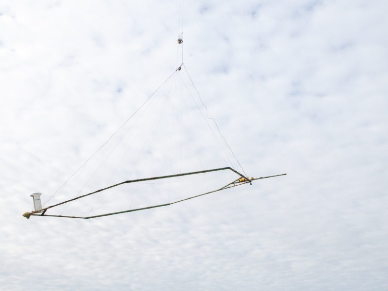
AEM uses large hoop frames dangled from helicopters that bombard the earth with radio waves and measure the responses to determine what materials are underground down to 1,000 feet deep. InSAR uses satellite radar waves to measure how much the earth’s surface has sunk or bulged upward to determine how water moves underground.
Regular flights
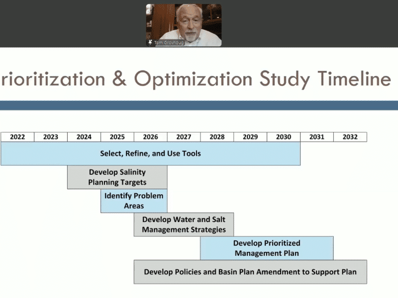
AEM technology has advanced to the point that the state Department of Water Resources will begin regular helicopter surveys over California groundwater basins starting this summer. The flights will begin in the Salinas Valley and may reach the San Joaquin Valley by fall, but flights haven’t been scheduled that far out yet.
The data could have significant implications for agencies tasked with implementing California’s Sustainable Groundwater Management Act, signed into law in 2014. SGMA’s aim is to bring groundwater basins into balance, meaning more water isn’t pumped out than goes back into the aquifer, by 2040.
SGMA required the formation of Groundwater Sustainability Agencies to manage basins on a local level.
But knowing how to manage groundwater is difficult when you can’t see anything beneath the surface. That’s where the new technologies may help.
“I describe it as one of those high definition ultrasounds that new mothers-to-be have,” said Eric Osterling, general manager of the Greater Kaweah groundwater agency, of the AEM surveys.
The Greater Kaweah groundwater agency covers a horseshoe-shaped area in Tulare county that runs south of Hanford, east of Visalia and swings back south and west toward Corcoran.
The entire Greater Kaweah groundwater basin was mapped using AEM in 2018 through a collaboration between three groundwater agencies, including Greater Kaweah, and Rosemary Knight, a George L. Harrington Professor of Earth Sciences at Stanford University.
Proposition 68, a $4 billion parks and water bond passed that same year, included $12 million specifically for AEM flights.
The Department of Water Resources is using that money for regular AEM surveys starting this summer through 2024 to build a comprehensive dataset of the San Joaquin Valley.
Osterling said the Kaweah subbasin data will play a fundamental part in its groundwater management, especially when it comes to halting subsidence.
“We really were in the dark,” said Osterling, in reference to understanding its groundwater picture. “We really had to kick the can on subsidence.”
Sinking damage
The worst subsidence occurs where clay sits between sand and gravel. When too much water is extracted, those layers can pancake, causing the overlying land to collapse. That has already created serious problems for canal systems, including the Friant-Kern Canal along the valley’s eastern edge, which brings water from Millerton Lake north of Fresno to towns and farms 152 miles south all the way to Arvin.
Sinking land along a 33 mile section of the Friant-Kern Canal from about Pixley in southern Tulare County to Lake Woollomes in northern Kern County, has reduced the amount of water the canal can carry by 60%. Repair cost estimates are about $500 million. So, it’s vital for farmers and water managers to better understand how areas are affected by groundwater pumping.
AEM Survey data is used to create a map so managers can see which areas to avoid.
Those maps can also show where to put water in times of abundance so it percolates down and recharges the aquifer. If water isn’t put in the right areas, it can sit on the surface and even damage crops.
Some landowners are planning million-dollar water recharge projects, said Aaron Fukuda, general manager of Tulare Irrigation District. Building in the wrong places could be a huge waste of money.
“Everybody is running around panicked because we’re in a potential second long drought period,” Fukuda said. “A lot of people are grasping for straws. If we only have a limited amount of dollars we’ve got to focus that on things that work.”
Data from the AEM surveys could help pinpoint the best recharge ground.
“Groundwater scientists and managers today are where doctors were at the start of the 20th century, needing to understand something about a region they can’t see,” said Knight.
Mapping ancient pathways
She recently partnered with natural resource mapping company Aqua Geo Frameworks and used AEM surveys to find ancient underground pathways, called paleochannels, in the foothills of the Sierra Nevada mountains. Paleochannels formed when glacial rivers carved through the foothills thousands of years ago.
The paleochannels could be used to convey flood water directly into valley aquifers for recharge. As storms and flooding become more intense due to climate change, knowing how to move that water is critical, said Knight.
But electromagnetic surveys aren’t perfect.
They’re expensive at $350,000 for a single 500-mile line flight. And the resolution isn’t always great because the surveys pick up “big packets” of the subsurface, said Fukuda.
“Wild west” of data
Other scientists, meanwhile, have been using InSAR to measure San Joaquin Valley surface level changes to better understand groundwater movement.
Over a two-year period, researchers at the University of California San Diego’s Scripps Institution of Oceanography used satellites to bounce radar waves off the valley.
Depending on how wet or dry each year is, scientists can compare the images to tell how the ground has changed over time.
Areas where the ground uplifts after a dry year can show where subsurface water is and how it’s moving. It’s like tracking a “pulse of water through the system,” said Wesley Neely, PhD candidate at Scripps and lead author of a paper on the San Joaquin Valley InSAR work.
Understanding groundwater flows could help groundwater agencies better manage their subbasins.
The satellite research could also be combined with the helicopter surveys to create an even more complete image of the valley’s groundwater, said Neely.
“It’s a little bit of the wild west of what we can do with our data,” said Neely. “This will be an extremely important tool going forward.”