Nuts getting a bad rap for sinking the California Aqueduct
State water officials are blaming almond and pistachio orchards for sinking the California Aqueduct before all the evidence is in, according to one western Kern County water district manager.
“They need to do more homework,” said Jason Gianquinto, General Manager of the Semitropic Water Storage District. “It’s easy to say, ‘Hey, this area is subsiding and, by the way, there’s ag here.’ But it’s not taking into account where the water for that ag is coming from.
“It’s a knee jerk reaction.”
Gianquinto referred to a report issued by the Department of Water Resources on Dec. 31 that put the blame for several areas of Aqueduct subsidence on heavy groundwater pumping in order to sustain a massive increase in orchard and vineyard plantings.
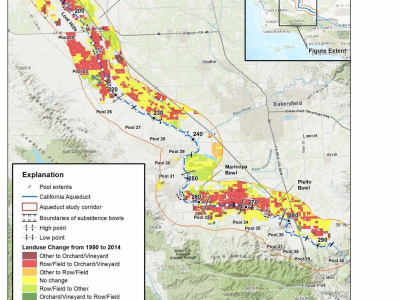
In Lost Hills, which is covered by the western fringes of Semitropic, a section of the Aqueduct has dropped up to four feet, according to the report.
“Subsidence around Lost Hills is a valid concern,” Gianquinto said. “But there isn’t a lot of groundwater production out there. It’s too salty. Most of the crops in that area rely on surface water.”
Semitropic does pump groundwater. In fact, it pumps so much groundwater it’s overdrafting by between 165,000 and 256,000 acre feet a year, according to its groundwater sustainability plan.
But, in regards to subsidence on the Aqueduct, where Semitropic farmers pump is potentially more important than how much they pump, according to Gianquinto.
Very little groundwater pumping is done west of the Buttonwillow Ridge, a geologic barrier which runs along the east side of the Aqueduct, he said. Most of Semitropic’s growers pump east of that ridge.
“(The state) need to look at the geology and see if there is much, if any, groundwater communication east to west. And which zones are collapsing? They looked a lot at crop conversion, but they need to do a deeper dive on the geology before they start pointing fingers.”
It appears, however, that finger pointing has already commenced.
Days before the Dec. 31 report was released, DWR fired off comment letters to several Groundwater Sustainability Agencies with borders along the Aqueduct letting them know the state considers subsidence a top issue.
In Dec. 26 comments sent to the Kern Groundwater Authority, DWR wrote: “GSP (groundwater sustainability plan) Section 3.1.3 Undesirable Results for Land Subsidence, contains the following sentence: ‘While it is generally acknowledged that subsidence exists within the Subbasin, there are generally no significant impacts to infrastructure within the Subbasin.’ We disagree with this conclusion, as subsidence has reduced the flow capacity of the Aqueduct by 19% near Highway 46.”
The state letter also warns KGA not to try and pin responsibility for subsidence on oil production: “GSP states that subsidence associated with oil and gas activities may also occur within the Subbasin. In fact, the March 2019 report finds that oil extraction from the Lost Hill Oilfields did not have a significant contribution along the Aqueduct.”
The same day DWR sent that letter, similar letters were sent to Westlands Water District and groundwater sustainability agencies in the Tulare Lake Subbasin and the Northern and Central Delta-Mendota regions.
The worst area of subsidence on the Aqueduct appears to be in the southern portion of Westlands in western Fresno County.
That section of the Aqueduct, known as Pool 20, has already sunk up to six feet.
DWR wrote of Westlands’ groundwater sustainability plan: “The GSP assumes that ‘residual subsidence’ of 0.1 foot per year will be acceptable on the Aqueduct. We are concerned that if this rate of subsidence continues through 2040 and possibly thereafter, it will further adversely impact the Aqueduct’s conveyance capacity and operational flexibility.”
Calls to Westland’s General Manager Tom Birmingham were not returned.
Groundwater sustainability agencies have until Jan. 31 to revamp their plans and submit them to DWR for approval.

Conversion along the Aqueduct to permanent crops from row crops (in red) in Kings County 1991-2014

Conversion along the Aqueduct to permanent crops from row crops (in red) in Fresno County 1986-2014

Conversion along the Aqueduct to permanent crops from row crops (in red) in Merced County 1995-2014