Kern River: “Best kept secret” demystified through technology
There’s a new way to explore the Kern River and it can all be done from the comfort of your own home.
The nonprofit Kern River Parkway Foundation has sponsored a visual mapping of the Kern River. Volunteers set out along the river on the parkway’s bike path and down some of the river in a kayak equipped with GPS and 360-degree cameras to capture the river for Google Maps Street View.
“I really felt like the river needed to be demystified for local residents,” said Matt Mayry, technical volunteer with the foundation who kayaked the river for the mapping project. “It really is Bakersfield’s slice of heaven that most people don’t know about.”
To see the photos and virtually travel along the river, go to Google maps and type in Kern River. Zoom in to the section you want to explore. Then go to the bottom, right hand corner of the map and drag the little yellow person icon to that section. Drop the icon onto the map and a new screen will pop up with 360-degree views of that area. You can use the arrow keys on the new screen to “scooch” around and see more of the hiking path and river.

The section of the Kern through Bakersfield is often completely dry. But because of the historic storms this year, the river is still flowing all the way through town. It was an opportunity for Mayry to paddle and document parts of the river that often aren’t alive.
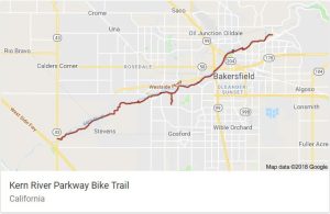
So far, Mayry has mapped the river from Panorama Vista Preserve in Bakersfield down to Allen Road on the west side of town. That entire section is normally dry, he said.
There is more mapping to be done.
The project will continue capturing imagery on the river as far downstream as possible toward the Kern Water Bank west of Bakersfield. Volunteers will also map upstream where the river flows all year and may also work on mapping some of the Upper Kern near Kernville in collaboration with local businesses there, said Mayry.
The Kern can often be dangerous so Mayry scouted the routes beforehand, wore a lifejacket and got out of the river to walk around weirs.
The bike path portion of the project is completed. The 30-mile bike path has been captured on camera and is in the process of uploading onto Google Maps though there have been some technical difficulties.
The project was sponsored by the Kern Parkway Foundation which purchased the 360-degree cameras, GPS unit and tripod.
The visuals can help people plan trips and find new spots to explore, said Mayry.
“I think that is a huge benefit to local residents to know that yes, you can get in the water,” said Mayry. “Get in with a guide, you can book a trip.”
Companies such as River’s End Rafting & Adventure Co. take people down the river and help people safely explore the Kern, said Mayry.
“Spread the word,” said Mayry. “It’s the best kept secret in town.”