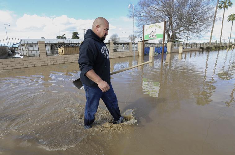
The same day that water gushed over the banks of Miles Creek swamping the small town of Planada in Merced County last month, the Newsom’s administration pulled $40 million out of its proposed budget that was intended for flood protection projects in the San Joaquin Valley.
Advocates had worked for years to get that money into the budget, which was approved by the Legislature and signed by the Governor last fall. It would have supported up to eight projects throughout the valley, including two potentially along the Kern River.
“That was super disappointing,” said former Assemblymember Adam Gray, of the pending funding cut. Gray represented the Merced area for a decade before narrowly losing a bid for Congress this past fall.
He said the funding would have gone to River Partners, a nonprofit river restoration group, to find “optimal locations in the San Joaquin Valley to do habitat restoration that would also provide flood control and groundwater recharge.”
“In light of the flooding that happened here in Merced, it’s really counter productive,” Gray said of the administration’s funding pull back. “Not only should the state be spending $40 million a year on this sort of infrastructure, it should be spending $400 million a year.”
The administration gave itself some wiggle room by stating the $40 million could be restored “if General Fund conditions improve,” according to a representative for Wade Crowfoot, secretary of Natural Resources.
Few funding options
And though the representative wrote in an email that funding for San Joaquin Valley projects such as floodplain restoration is available through other programs, that hasn’t been River Partners’ experience, said Julie Rentner, president of River Partners.
She said her group has had funding turned down for floodplain restoration projects from a host of different programs administered by Natural Resources, Department of Fish and Wildlife, the Wildlife Conservation Board and the Department of Conservation.
“The reason Adam Gray championed this funding allocation is because the programs have not been funding this work at the pace and scale we need to get ahead of the growing risks of flooding, extinction, and extreme drought,” Rentner said.

Rentner hopes the funding is restored by the time the Governor’s revised budget comes out in May.
Beyond that, she said she’s heard rumblings that legislators may introduce a bond measure to support valley flood projects on a larger scale along with other climate resilience work across California. A flood protection bond bill was introduced by Assemblymember Carlos Villapudua, D-Stockton, earlier this year but hasn’t been fleshed out yet.
Meanwhile, flood protection in the southern San Joaquin Valley remains under a hodgepodge of different agencies with no significant state funding or oversight.
Future flood scenarios “alarming”
“Of any place in California dealing with fallout from a warming climate, I’m most concerned about the southern half of the Central Valley,” said Daniel Swain, a UCLA climate scientist studying the impacts of extreme weather.
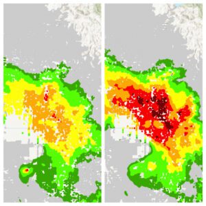
The Sierra Nevada mountains are higher east of towns such as Fresno and Visalia. As climate change pushes the snowline upward and the state is pummeled by warmer winter storms with heavy rain, that could create a scenario where a massive amount of snow at high elevations melts off in a downpour and barrels toward the valley.
“We’re seeing the potential for runoff peaks 200 to 400 percent larger than historic runoff peaks,” Swain said. “Those numbers are actually shocking to those of us who’ve been studying this.”
Combine those projections with increased population throughout the valley and the fact that flood management has been woefully underfunded in most valley areas and, Swain said, the prospect is “alarming.”
“Even people who don’t accept our work on climate agree the south is more at risk for its demographics and the physical realities,” Swain said.
Solutions studied, little done
Despite that acknowledgement, funding for flood protection in the San Joaquin Valley lags about 10 to 1 compared with resources for the Sacramento region and other northern areas, Rentner said.
That disparity isn’t lost on locals
“It just seems the further south you come, the less interested the state is,” said Mark Mulkay, formerly the General Manager for Kern Delta Water District, which has dealt with major flooding issues on the Caliente and Walker creeks that regularly inundate the small town of Lamont in southern Kern County.
“Solutions for Lamont have been studied and restudied and not much has been done,” he said.
The same has been true for a number of small valley towns.
In Huron, it took residents pushing for more than two decades to get funds to build an adequate bridge over the Arroyo Pasajero creek, which would flood out northern access to Highway 269 in big water years. That’s why six Huron residents died during a huge flood in 1995, said Huron Mayor Rey León. They had to take the long way around using Interstate 5 where a bridge collapsed, swallowing their car.
“The struggle for this has gone on forever,” he said.
Through a combination of funding from Fresno County’s Measure C and Senate Bill 1 money, Huron got the $31 million it needed to build the bridge project, which finally broke ground in 2018.
Having adequate infrastructure has been a game changer in Huron, which lost out on attracting businesses afraid of being trapped when 269 closed, León said.
Even with the problem “solved,” though, León was out taking video as water rose under the bridge during January’s storms and notifying residents on his Facebook page. Had the storms continued, he said, he’s not sure what would have happened.
He wasn’t aware of the $40 million pulled from the Governor’s proposed budget but said, “Unless the Governor has another pot of money to take care of these communities, that doesn’t sound right.”

Flood plains changing
An added twist to flood planning and protection in the valley is subsidence, land sinking.
As drought and regulatory restrictions have cut surface supplies, farmers have pumped enormous amounts of groundwater, causing the land to collapse over large areas. NASA has been tracking the sinking, particularly around Corcoran in Kings County, using satellite technology since the last drought in 2015.
In fact, Corcoran residents had to approve a special tax in 2017 to help fix the town levee at a cost of $10 million because it had sunk below protective levels. It has continued to sink.
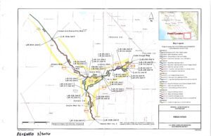
Subsidence is also known to have changed at least some historic flood zones, according to a 2017 engineering report on the Corcoran area commissioned by the California High Speed Rail Authority.
It noted that because of subsidence, the historic Poso Creek “flood zone will likely merge with the Deer Creek and Tule River flood zones,” resulting in a potential flood depth of 16 feet for 20 miles along the rail line now under construction.
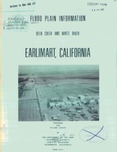
Water from those creeks have regularly flooded the small towns of Earlimart, Alpaugh, and Allensworth.
The 2017 report also notes that The Kings River could also contribute to flood problems, though most of that water could be controlled with the right infrastructure.
“However, currently there is no entity responsible for or with authority to study or implement such a coordination effort, nor is there funding in place for any such improvements,” the report states. “Federal, State and local flood agencies are aware of the potential issues in the Tulare Lake flood zone.”
Downhill is uphill now
When flood does come, “There’ll be a new lake basin and a lot of dairies will be under water,” said Jack Mitchell, a longtime rancher in the Atwell Island area of Tulare County and head of the Deer Creek Flood Control District. The district maintains about five to seven miles of channels on the Deer and Poso creeks and on the White River.
He said the district had its elevations calculated recently and discovered land to the north of Alpaugh has sunk 18 to 24 feet in the last few years,Mitchell said.
If the creeks flood big, the district will have to rely on six large pumps staged north of Alpaugh by the Boswell Farming Company to pump water up into the old Tulare Lake bed.
“What used to be downhill is uphill,” Mitchell said. “The lake bottom is higher than us now.”

System patchy but working
Most local flood managers felt that, even though the south valley has a patchwork system of agencies, local people are best equipped to deal with area rivers and uncontrolled streams.
On the Kings River, big water years, such as 2017 can be stressful, said David Merritt, General Manager of the Kings River Conservation District. But local agencies work together well, he added.
The district covers a huge area from Pine Flat Dam, west across the Tulare Lake Basin and north to the town of Huron. It’s responsible for 140 miles of levees over 1.2 million acres and operates on about $1.2 million in taxes from landowners. It also recently obtained $4 million in grants, Merrit said.
“We are all for local control. We’re here, we’re on the ground and we can react quickly,” Merritt said. “But if we could get more funding to improve floodplains, financially that would be great.”
Funding projects to reestablish floodplains along valley rivers and creeks just makes sense, said Dan Vink, Chair of the Tulare County Flood Commission and Principal Partner with Six-33 Solutions in Visalia.
He said agencies such as the Kings River Conservation District and Tulare Flood Commission do good work but, “On the ground, during floods, it does come down to the landowners and local agencies. And that can be haphazard in how things actually get done.”
Meaning, “Things can break down when people don’t feel the water is their responsibility – if it’s not affecting their land. That’s when there can be impacts to communities.”
Having a system of floodplains designated and ready to absorb excess water would be a good solution.
“Under SGMA (the Sustainable Groundwater Management Act), we’re going to have to take some land out of production. It might as well be lands that are prone to flooding and that would make good habitat and provide recharge,” he said. “It could be a really cool scenario.”

You must be logged in to post a comment.